Key Considerations
Highways and access
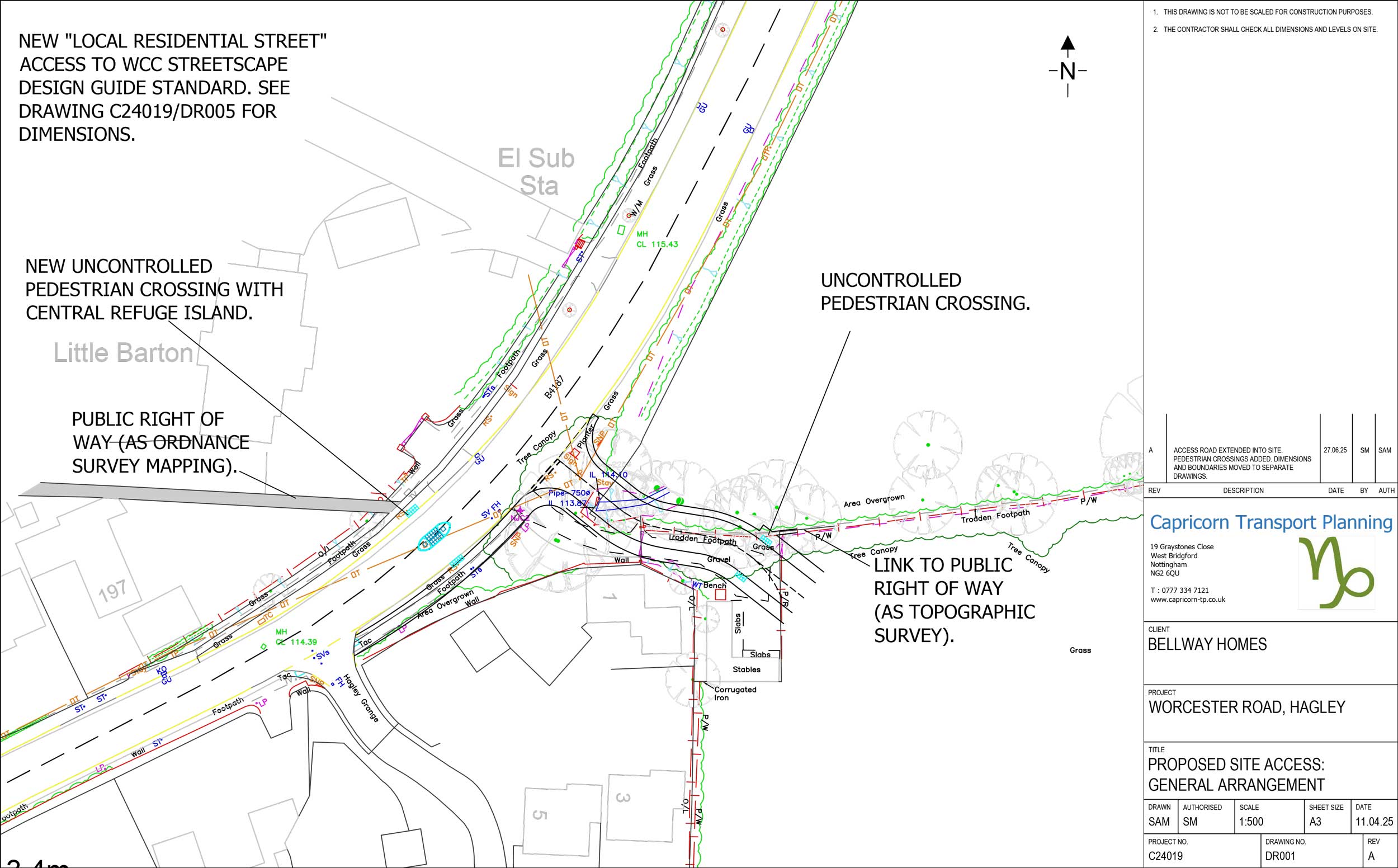
A Transport Statement (TS) has been produced to support and shape the proposed development.
It explains that the development access strategy comprises of:
- A simple priority vehicle access junction from Worcester Lane, at the existing site access location.
- Widening of the existing footway on the eastern side of Worcester Lane to 2.0m between the new site access junction and Hagley Grange.
- New uncontrolled pedestrian crossing on Worcester Lane, comprising dropped kerbs, tactile paving and a central refuge island to connect Footpaths 503(B) to the west and 512(b) to the east.
- A new 2.0m wide footway that will run along the southern side of the proposed new road, featuring an internal uncontrolled crossing to safely link pedestrians to the existing public right of way on the northeastern side.
- The site access junction and the curved section of the new street beyond, have been designed to accommodate the swept paths of a 10.52m long refuse collection vehicle (RCV).
- The proposed access provides an extension to the 30mph speed limit on the approach road (Worcester Lane), while the internal development street is designed for a low speed of 15mph due to its curves and safety considerations.
The TS sets out that the development benefits from excellent public transport links, providing access to regular bus services connecting to major centres like Stourbridge, Halesowen, and Kidderminster, as well as frequent train services offering an attractive travel option for commuters and longer-distance trips, especially to Birmingham, with connections to London and the wider national network.
Drainage
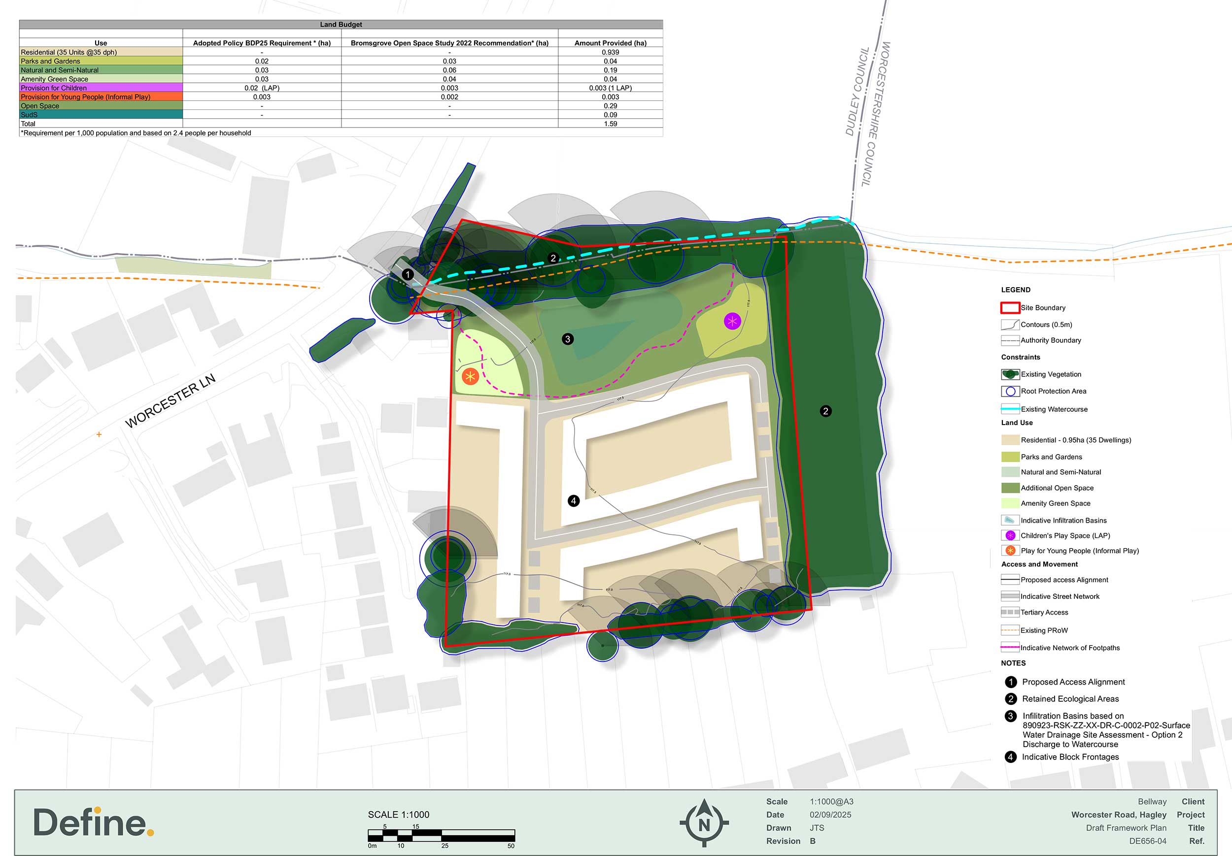
We’re planning to manage surface water on-site by installing an attenuation basin in the northern part of the site. This will temporarily hold rainwater during very wet weather and allow it to soak naturally into the ground over time. This system will help avoid flooding and reduce pressure on the local drainage network. The basin will be attractively designed with planting and open space around them, contributing to the green feel of the development.
Landscape and visual impact
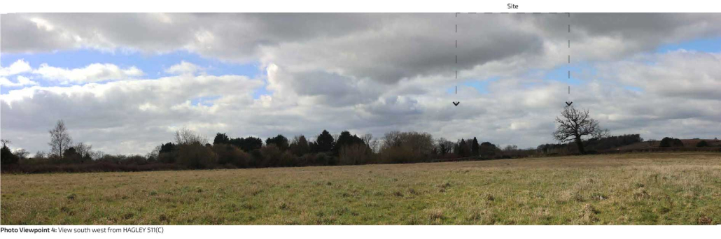
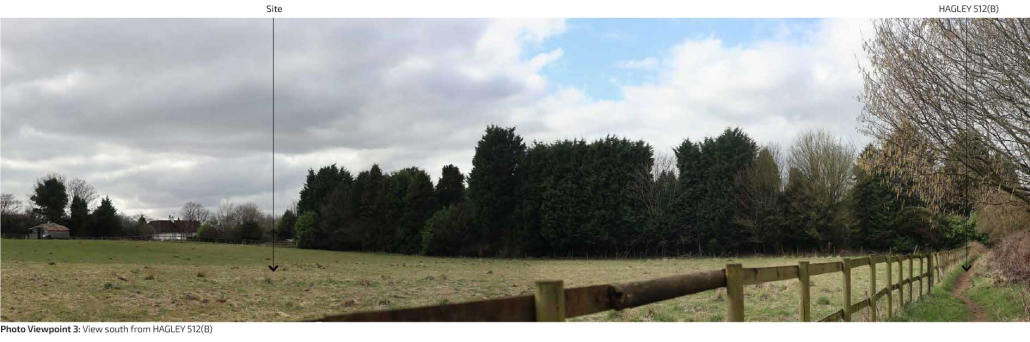
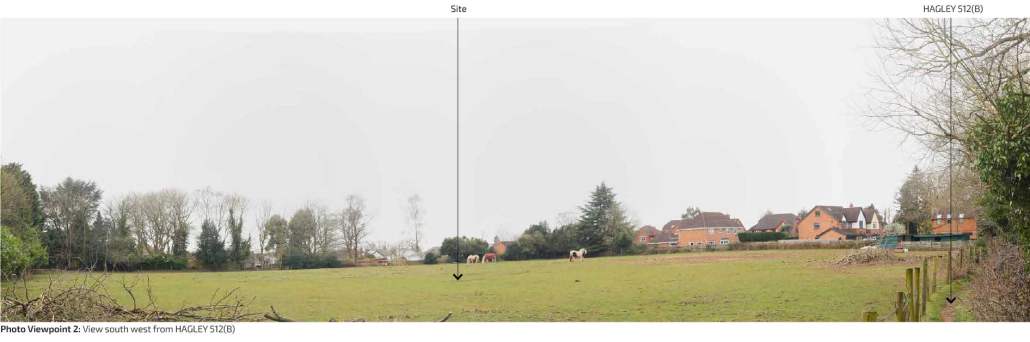
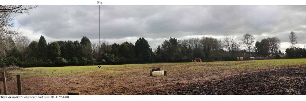
A Landscape and Visual Impact Assessment has been undertaken to assess the likely impact of the proposals on the surrounding views and landscape character. Key points from the document are set out below:
- The Site falls within the Estate Farmland Landscape Character Type (LCT). This is described as
-
-
- ‘An ordered agricultural landscape characterised by a sub-regular pattern of medium to large sized fields, small geometric plantations and groups of ornamental trees associated with large country houses. Settlement is largely restricted to discrete clusters of dwellings and occasional small estate villages.’
-
- The Site is partly reflective of the Landscape Character Area and displays some common elements however the Site also has urban influence as a result of the existing settlement edge. Whilst the proposed development would result in the loss of some open farmland at the edge of the settlement, this would represent a relatively small area of land in the context of the wider landscape character area, and the influence of the development on the wider landscape character would be very limited, due to the retained boundary planting.
- The proposed development will not be introducing Minor / Negligible Adverse once planting to the north has established, helping the built development to assimilate with its surroundings.
- The most noticeable impact of the proposed development will be the loss of openness associated with the replacement of pasture at the settlement edge by new residential development and associated Green Infrastructure. However, the new housing will be comparable in scale and character to the existing settlement edge and will be visually contained by retained and proposed tree and hedgerow planting. The Site is already influenced by built development to the west and south, and its existing boundary vegetation, including hedgerows and mature trees, will be retained wherever possible. The northern edge of the Site will contribute to the wider Green Infrastructure network, and it is anticipated that, once the proposed planting has matured, this will deliver localised landscape benefits. As a result of these measures, the overall landscape effects are considered to be Moderate Adverse initially, reducing to Moderate/Minor Adverse by Year 15 as the proposed mitigation establishes.
- Overall, the effects are mainly limited to the change to the site itself and private views from the neighbouring properties, and from a short section of footpath 512 B. There would be minimal landscape or visual effects beyond this area. The proposed development would not result in any unacceptable impact on landscape character or visual amenity.
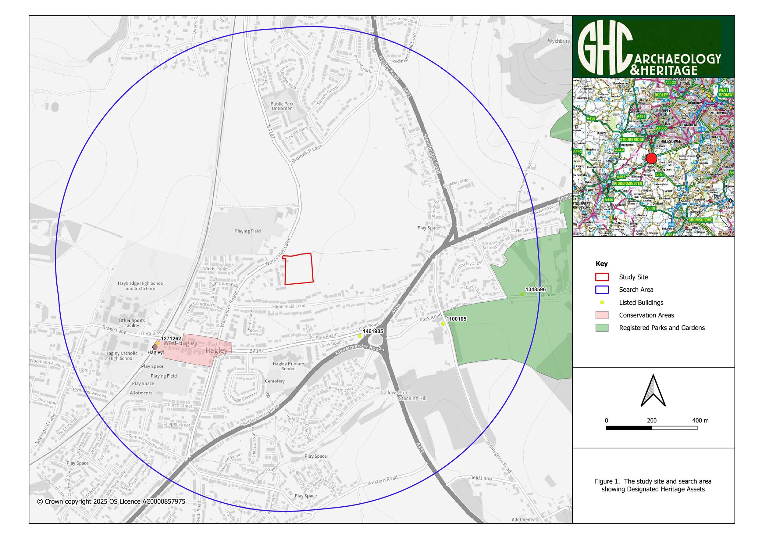
Heritage
There are no listed buildings or protected heritage areas on the site itself. A Heritage Assessment has concluded that the development will cause no harm to designated heritage assets in the wider area. Although the wider area does have some historically significant sites, including Hagley War Memorial, they’re well screened by trees. We’ll continue to ensure the design respects the area’s character and history.
Ecology & Trees
We’ve carried out or scheduled a full set of wildlife surveys, including for birds, bats, great crested newts and other species, alongside arboriculture and ecological assessments. The assessments conclude:
- The Site is not afforded any protection as a statutory or non-statutory designated site, and development of the Site is not expected to affect the conservation value of any designated site.
- The habitats forming the main area of the Site are of relatively low ecological importance comprising heavily grazed grassland, artificial, unvegetated sealed surface and a stable.
- The proposals have retained the majority of the woodland to the north of the site and buffered the woodland from the proposed development. However, to facilitate the Site access, an area woodland will be removed. With the implementation of long-term management within the woodland and the provision of species rich grassland adjacent to the woodland it is likely that the proposals will result in an overall positive effect to this receptor.
- The tributary of the Hagley Brook represents an ecologically valuable feature and measures to prevent pollution and soil run-off are required.
- No bat roosts have been identified with buildings or trees, but the presence of foraging / commuting bats has been recorded including some notable/rarer species. Current activity was largely restricted woodland edge at the north of the Site and the eastern boundary.
- The site has been assessed in line with BNG legislation, and we are looking at a range of options to deliver the 10% net gain.
- Access requirements necessitate the removal of trees, primarily consisting of lower-value specimens and a minimal number of moderate-value trees. This is the full extent of tree removal proposed, as it is strictly necessary to establish a safe site entrance. All remaining trees are retained.

